
kerryellis
FollowViews
2153
Likes
Awards
Contest Finalist in Architecture And Reflections Photo Contest
Peer Award
Absolute Masterpiece
Superb Composition
Top Choice
Magnificent Capture
Outstanding Creativity
Virtuoso
Superior Skill
Genius
All Star
Top Ranks
Categories
Same photographer See allBehind The Lens
Discover more photos See all
Behind The Lens
Location
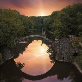
This is a shot of Schloss (castle) Albrechtsburg, located on the Elbe River in the city of Meissen, Germany, not too far from the city of Dresden.Time
This image was shot at around 9pm, during the twilight hour.Lighting
The lighting of the sky is natural. The lighting of the castle and town are man made, of course. The water reflection too is natural as the Elbe at this area is placid and slow moving.Equipment
I used my Nikon D810, tripod mounted, with a Nikkor 24-70mm f2.8 lens.Inspiration
I have a passion for castle shots, so I travel around Germany and Europe taking photos of various castles. I had seen on-line images of this castle, so I wanted to capture some of my own images of it. I was fortunate with this image as I had ideal lighting on the only night I had to shoot this particular castle.Editing
I did some post processing, all of it in Adobe Lightroom. This image did not need much post tweaking. I bumped up the shadows and lowered the highlights, bumped up the clarity and contrast a tiny bit, but that's about it.In my camera bag
I normally have my D810 camera, Nikkor 14-24 f2.8, 24-70 f2.8, 70-200 f2.8 and Sigma 50mm f1.4 in my bag. For landscapes such as this I normally have my Manfrotto 190 Tripod.Feedback
To capture images like this other then the photography equipment I listed above I make use of a number of apps. First, I use several weather apps so I can better plan for what kind of sky/light I might get. I use accuweather, and the app that comes with the iPhone, and Storm Underground. Another app I use which I recommend for any landscape photographer is The Photographers Ephemeris. I can't say enough about this free app and I rely heavily upon it. It makes use of Google Earth, which provides a satellite image of anything on earth you might want to photograph. This allows you to zoom in and study the area, surrounding features, etc. It also shows the angle in relation to the subject, and the exact time of Sunrise and Set at that location. A third feature is it provides longitude and latitude grid numbers that you can plug into a navi allowing you to drive/hike/bike, to the exact location of your choosing. For a navi I use Google Map and Tom Tom to preload all the ares of a region of city that I want to photograph. Then, if in a city, I bike from location to location. For travel to various locations I use Air bnb, Hotels.com and expdia.com.


